Monitorización Dinámica – Parque Eólico Marítimo, Blyth
Challenge
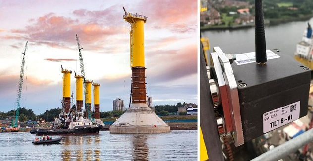
The Blyth Offshore Demonstrator Project is an ambitious project delivered by EDF Energy Renewables, showcasing groundbreaking and experimental construction techniques. It consists of 5 wind turbines with a combined generation capacity of 41.5MW, enough low carbon energy to power 34,000 homes, whilst cutting annual CO2 emissions by 57,600 tonnes.
The turbines make use of a concrete Gravity Based Foundation (GBF) for support, which were constructed by BAM using a technique called Float & Submerge, where they were constructed on land, floated down a river and submerged to the sea floor.
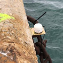
BAM performed inclination tests to define the exact centre of buoyancy for the GBFs to confirm the stability during tow and installation. A reliable inclination system was needed to demonstrate that they were as stable as the design had predicted they would be during the towing and final submersion. Based upon other successful deployments for BAM, and a reputation for being world leaders in wireless remote condition monitoring, Senceive was asked to provide a solution.
Solution
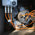
Two high precision triaxial tilt nodes were positioned around steel platforms on top of each of the GBF’s steel shafted masts, complete with waterproof straight antennae. Senceive’s patented magnetic mounting system allowed the tilt nodes to be quickly installed in any orientation, with each unit having a magnetic pull force of 100Kgs. The BAM team responsible for monitoring the GBFs asked for the two triaxial tilt nodes to be installed at a right angle to each other, which served two purposes: To provide redundancy in the unlikely event of failure or node disturbance and corroboration of the readings.
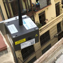
The nodes were all set to an initial reporting rate of 1 minute for the dry dock testing period (increased to 1 second later on) and trigger levels were preset to alert users via SMS text message. Data was then relayed through each mast’s own Solar 3G Gateway and wirelessly communicated through the FlatMesh network to the Senceive WebMonitor visualisation software, which can be accessed by registered users on any tablet, smart phone or computer worldwide.
Outcome
BAM needed to demonstrate that the built GBFs were as stable as the design had predicted it would be during the towing and final submersion, so monitoring was extended a further month and BAM also requested that the reporting rate be increased to a real-time level of 1 Hz.
The innovative Float & Submerge method used proved highly successful with the only movement shown in the dynamic data being that of the tides. The system had the advantage of swift easy installation and proved its reputation for robustness and reliability in harsh and challenging environments.
Sectores de aplicación de los sensores de Senceive y Omnidots

Auscultación vía ferrea
Auscultación de superestructura o vía; peralte, alaveo y perfil longitudinal. Monitoreo de infraestructura. Convergencias, deformaciones y subsidencias en túneles y puentes
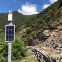
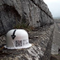
Monitorización de taludes
Alerta temprana de movimientos y desprendimientos
Auscultación de edificios
Auscultación de superestructura o vía; peralte, alaveo y perfil longitudinal. Monitoreo de infraestructura. Convergencias, deformaciones y subsidencias en túneles y puentes
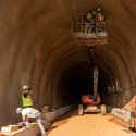
Monitoreo de túneles
Convergencias Asentamientos
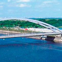
Auscultación de puentes
Monitoreo y auscultación de puentes
Geotecnia
Excavaciones profundas, auscultación y monitoreo, movimientos del suelo y subsuelo, automatización de instrumentación geotécnica, inclinómetros, IPI, piezómetros, células de carga, extensómetros
Auscultación de minas
Monitoreo y auscultación de minas a cielo abierto o subterraneas
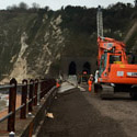
Auscultación de carreteras
Control de taludes, firme, tuneles en tiempo real

Patrimonio
Monitorización obra de fábrica para predicción y mantenimiento de edificios y estructuras
Infraestructuras especiales
Auscultación de superestructura o vía; peralte, alaveo y perfil longitudinal. Monitoreo de infraestructura. Convergencias, deformaciones y subsidencias en túneles y puentes
Energía
Monitoreo y auscultación de presas, oleoductos, parques eólicos, chimeneas, estabilidad, deformaciones, presión, tensión, pruebas de carga
Auscultación en topografía
Las nuevas oportunidades del topógrafo en la auscultación y monitorización por sensores